Urban Design Frameworks

An urban design framework (UDF) is a detailed planning and design document, otherwise known as a strategic plan, that sets a long-term integrated design vision to guide the future use and development of an area.

Within the City of Melton’s growth areas, the preparation of UDFs are generally required through a Precinct Structure Plan (PSP) and its accompanying Schedule to Clause 37.07, the Urban Growth Zone before subdivision or development can occur.

Upon completion of a UDF, planning permit applications can be lodged within the UDF areas. Council planners will assess the permit application against the UDF (along with other relevant planning policy such as a PSP) to determine if the proposal is in line with the vision, requirements and guidelines of the UDF.

More information regarding approved UDFs or UDFs in development can be found below.

Aintree Major Town Centre Urban Design Framework (Aintree MTC UDF)

We have prepared an updated Urban Design Framework (UDF) for the Aintree Major Town Centre.

An Urban Design Framework (UDF) is an integrated vision for the area and guides its use and development over time through urban design principles, objectives, planning and design requirements and guidelines.

It is also the framework for assessing future planning permit applications (ie development proposals).

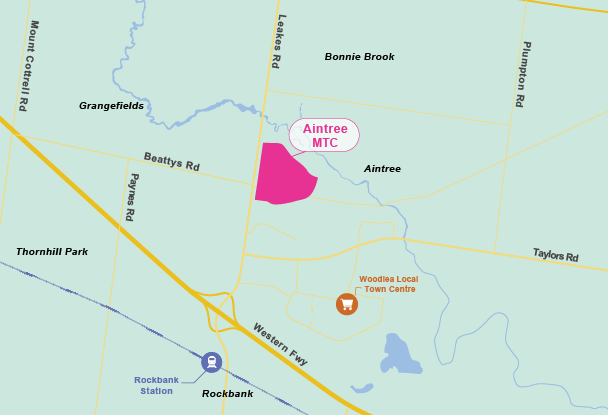
The town centre is approximately 47 hectares in size and will be located in the suburb of Aintree that will serve the immediate and wider area as a hub for shopping, services, food, and entertainment. 

The UDF is expected to create significant areas that will be set aside for retail, commercial, health and areas set aside for high amenity and high-density residential outcomes. The future town centre will also be home to a substantial increase in local jobs.

Project Status Update

In October and November 2023, we asked for feedback on the proposed draft UDF.  Due to the complexity of the key matters raised in submissions by state government agencies requiring additional investigations, the UDF was placed on hold.

In collaboration with state agencies, the UDF was updated in 2025 to reflect the feedback received and the final document was completed in late August 2025.

The UDF is expected to be considered by Council in late September 2025. Once approved by Council, planning permits can be assessed against the vision and guiding principles of the UDF for works to commence.

Download and view the Draft Aintree Major Town Centre Urban Design Framework(PDF, 20MB).

Location of Aintree MTC

Aintree MTC Location

Consultation

The Aintree UDF was open for consultation from 16 October to 13 November 2023. Thank you to the stakeholders, landowners and interested community members who have put in a submission, attended the community consultation workshop, or called to discuss this project.

Council has reviewed all submissions and met with submitters to resolve any outstanding matters. 

Background and Technical Reports

As part of the UDF process, a background report was prepared. The Background Report was finalised in August 2023 and included technical reports and modelling for traffic, drainage and flood modelling, and an economic assessment peer review which can be viewed from the links below:

For more information, please call our Strategic Planning Team on 9747 7200 or email citysupport@melton.vic.gov.au

Mt Atkinson Major Town Centre Urban Design Framework (Mt Atkinson MTC UDF)

The Mt Atkinson Town Centre is a proposed Major Town Centre that is identified in the Mt Atkinson and Tarneit Plains Precinct Structure Plan (PSP). The draft Urban Design Framework (UDF) is currently under preparation and is expected to be ready for consultation shortly.

The UDF envisions a vibrant Town Centre, situated next to a proposed train station, with a variety of uses. The types of uses will include retail, offices, community facilities, open spaces, food, entertainment and higher density residential outcomes adjacent to the town centre and train station.

Project status update

Council has been working with stakeholders to prepare a draft UDF for the Mt Atkinson Town Centre.

Public consultation is likely to take place late 2025, subject to the submission of the updated draft UDF from the landowner and subject to Council’s endorsement to release the draft UDF for community engagement.

Following the consultation period, the UDF is expected to be formally considered by Council early 2026.

Once approved, future planning permits (i.e. development proposals) can then be considered and assessed by Council against the approved UDF.

Bloomdale Employment Precinct Urban Design Framework

Bloomdale is approximately 35km north-west of Melbourne’s Central Business District and can be accessed via the Calder and Tullamarine Freeways from Melbourne. The Urban Design Framework (UDF) has been prepared for the proposed employment precinct, Lot J and Lot I, License Road within Bloomdale Estate, Diggers Rest.

This UDF has been prepared in line with the requirements set out in the Diggers Rest PSP.

The approved Bloomdale Employment Precinct UDF can be downloaded from the link below or can be viewed at Melton Civic Centre, 232 High Street Melton.

Bloomdale Employment Precinct Urban Design Framework(PDF, 28MB)

Cobblebank Metropolitan Activity Centre Urban Design Framework (CMAC UDF)

Melton City Council and Tract Consultants commenced work on the Cobblebank Metropolitan Activity Centre Urban Design Framework (CMAC UDF) in August 2017.

The CMAC UDF was adopted at the Ordinary Meeting of Council on 9 December 2019.

Replacing the Toolern Town Centre UDF 2012, the CMAC UDF covers approximately 100 hectares of land that is intersected north-south by Ferris Road and east –west by the Melbourne-Ballarat railway line.

The CMAC is designated in the State government’s metropolitan planning strategy, Plan Melbourne 2017-2050 as an emerging metropolitan activity centre identified as ‘Toolern.’  Other metropolitan activity centres include Box Hill, Broadmeadows, Dandenong, Epping, Footscray, Fountain Gate – Narre Warren, Frankston, Ringwood and Sunshine and the other emerging centre of Lockerbie.

Plan Melbourne 2017-2050 identifies a Metropolitan Activity Centre as a higher order centre providing a diverse range of jobs, activities and housing for regional catchments that are well serviced by public transport. Metropolitan Activity Centres also play a major service delivery role, through government, health, justice and education services as well as retail and commercial opportunities.

The adopted CMAC UDF can be downloaded from the link below or can be viewed at Melton Civic Centre, 232 High Street Melton.

Cobblebank Metropolitan Activity Centre Urban Design Framework(PDF, 4MB)

Background and Technical Reports

At the beginning of the UDF process, a background report was prepared. The Background Report also included the Cobblebank Employment and Mixed Use UDF (CEMU UDF) as both UDFs were prepared simultaneously.

The Background Report was finalised in February 2018 and was informed through technical reports for economics and traffic and transport. An industrial buffer assessment was later prepared and is acknowledged in the Background Report as an addendum.

Further into the UDF process, a transport strategic modelling report was undertaken for both CMAC and CEMU UDFs which informed the traffic network in the draft CMAC UDF.

The above mentioned documents can be downloaded from the links below as well as the consultation report from the draft CMAC UDF stage.

Cobblebank Employment and Mixed Use Urban Design Framework (CEMU UDF)

Melton City Council and Tract Consultants commenced work on the Cobblebank Mixed Use and Employment Urban Design Framework (CEMU UDF) in August 2017.

The CEMU UDF was adopted at the Ordinary Meeting of Council on 9 December 2019.

The CEMU UDF area is approximately 490 hectares in size and is bound by the Western Freeway to the north, Mt Cottrell Road to the east, the Melbourne-Ballarat railway line to the south and the Toolern Creek to the West.

CEMU provides land for future light industry, warehousing, big box retail and office, to facilitate local job creation. CEMU also provides opportunity for a mixed use precinct towards Toolern Creek.

The adopted CEMU UDF can be downloaded from the link below or can be viewed at Melton Civic Centre, 232 High Street Melton.

Cobblebank Employment and Mixed Use Urban Design Framework(PDF, 3MB)

Background and Technical Reports

At the beginning of the UDF process, a background report was prepared. The Background Report also included the Cobblebank Metropolitan Activity Centre UDF (CMAC UDF) as both UDFs were prepared simultaneously.

The Background Report was finalised in February 2018 and was informed through technical reports for economics and traffic and transport. An industrial buffer assessment was later prepared and is acknowledged in the Background Report as an addendum.

Further into the UDF process, a transport strategic modelling report was undertaken for both CEMU and CMAC UDFs which informed the traffic networks.

The above mentioned documents can be downloaded from the links below as well as the consultation report from the draft CEMU UDF stage.

Exford Road Conservation Area Urban Design Framework

The Exford Road Conservation Area Urban Design Framework (UDF) was approved by Council on 19 April 2022.

Lot 4B on Exford Road is a 30 hectare site in Weir Views, Melton, located at the confluence of the Werribee River and Toolern Creek.

The site is of state significance both ecologically and culturally. The entire site is included on the Victorian Heritage Register (place H0316). The site is home to a remnant Grey Box Woodland and a heritage homestead. It also boasts a long frontage to the Melton Reservoir and Werribee River.

The approved Exford Road Conservation UDF can be downloaded from the link below or can be viewed at Melton Civic Centre, 232 High Street Melton.

Exford Road Conservation Area Urban Design Framework(PDF, 13MB)

Exford Road North Neighbourhood Activity Centre Urban Design Framework

The Exford Road North Neighbourhood Activity Centre Urban Design Framework (UDF) was approved by Council on 20 May, 2014.

The land subject to this UDF is located within the Toolern Growth Area, located south-east of the Melton Township and approximately 33 kilometres from the Melbourne CBD via direct access to the Western Freeway

The approved Exford Road North NAC UDF can be downloaded from the link below or can be viewed at Melton Civic Centre, 232 High Street Melton.

Exford Road North Neighbourhood Activity Centre Urban Design Framework(PDF, 4MB).

Hopkins Road Business Precinct Urban Design Framework

Council in collaboration with Mount Atkinson Holdings commenced work of the Hopkins Road Business Precinct Urban Design Framework (UDF) in 2020.

The UDF was adopted by Council at the Ordinary meeting of Council on 12 December 2022 and approved by the Victorian Planning Authority (VPA) Board on 14 December 2022.  

The Hopkins Road Business Precinct is a new employment precinct that is identified in the Mt Atkinson and Tarneit Plains Precinct Structure Plan (PSP). The Precinct is situated along the northern end of Hopkins Road that will provide office, commercial and large format retail, Industrial and light industrial opportunities.

The Mt Atkinson Precinct Structure Plan is forecast to create up to 19,000 jobs, with the Hopkins Road Business Precinct providing a significant portion of those jobs. With the proposed Western Interstate Freight Terminal (WIFT) located to the south and the proposed Outer Metropolitan Ring (OMR) located to the west of the precinct, the Hopkins Road Business Precinct is strategically located to contribute to a greater diversity of employment opportunities within the municipality and broader metropolitan context.

The Hopkins Road Business Precinct Urban Design Framework can be downloaded from the link below or can be viewed at the Melton Civic Centre, 232 High Street Melton. 

Background and Technical Reports

As part of the preparation of the UDF, a background report and associated technical reports on Traffic and Transport, Economics, Landscape Architecture and Servicing and Utilities were prepared.  These reports can be viewed via the links below, in addition to the Consultation Report:

Rockbank Major Town Centre Urban Design Framework Urban Design Framework

Council in collaboration with the Victorian Planning Authority commenced work on the Rockbank Major Town Centre Urban Design Framework (UDF) in 2017.

The UDF was developed by Melton City Council and Tract Consultants. The UDF was approved by the Victorian Planning Authority (VPA) Board in September 2019 and Adopted by Council on 14 October 2019. 

This town centre will be located near the Rockbank Train Station and serve the area as a hub for shopping, services, food and entertainment.

The Final Rockbank Major Town Centre Urban Design Framework can be downloaded from the link below or can be viewed at Melton Civic Centre, 232 High Street Melton.

Rockbank Major Town Centre Urban Design Framework(PDF, 5MB)

Background and Technical Reports

As part of the Urban Design Framework (UDF) process, a background report was prepared. The Background report was finalised in February 2018 and included technical reports for Economics, Traffic, Servicing and Utilities and can be viewed from the link below.

Seventh Bend Urban Design Framework

The Seventh Bend Urban Design Framework (UDF) was approved by Council on 6 August 2018.

Seventh Bend is located on Exford Road in Weir Views. The site is located within Melton City Council and is part of the Toolern PSP.  Seventh Bend is separated into three precincts. The UDF addresses the interface of Seventh Bend with Toolern Creek for Precinct Three only.

The approved Seventh Bend UDF can be downloaded from the link below or can be viewed at Melton Civic Centre, 232 High Street Melton.

Seventh Bend Urban Design Framework(PDF, 8MB)

Skylark Rise Urban Design Framework

The Sklylark Rise Urban Design Framework (UDF) was approved by Council on 31 March, 2020.

The subject site has a total area of 16.78 hectares, it is dissected by part of an unnamed road reserve and private property. The land is currently vacant undeveloped land containing some scattered vegetation throughout the site.  The site is located to the south of Bridge Road in Melton South located in the City of Melton, approximately 35km west of Melbourne’s Central Business District.

The approved Skylark Rise UDF can be downloaded from the link below or can be viewed at Melton Civic Centre, 232 High Street Melton.

Skylark Rise Urban Design Framework(PDF, 4MB)

Woodlea Local Town Centre Urban Design Framework

The Woodlea Local Town Centre Urban Design Framework (UDF) was approved by Council on 5 December 2018.

The LTC forms part of the broader Woodlea development which is located on a parcel of land of approximately 711Ha. Woodlea is accessed from Leakes Road with access to the Melton Highway to the north and the Western Freeway just to the south of the site. Woodlea is a fully integrated master planned community that in its ultimate form will include residential, employment, education, retail, commercial and community services.

The approved Woodlea Local Town Centre UDF can be downloaded from the link below or can be viewed at Melton Civic Centre, 232 High Street Melton.

Woodlea Town Centre Urban Design Framework(PDF, 33MB)

344-384 & 430-458 Exford Road, MELTON SOUTH Urban Design Framework

The 344-384 & 430-458 Exford Road, MELTON SOUTH Urban Design Framework (UDF) was approved by Council on 25 March 2020.

The site is located within the Toolern Precinct Structure Plan area with the Western Growth Corridor in Melton City Council.  It is located in Area 1, as identified in the PSP and is currently used for general farming purposes, including grazing and crop raising.  There are a few dwellings located in the southern portion of the area.

The site is noted in the PSP as a sloping land parcel in the south, east of Exford Road.

The approved Exford Road Conservation UDF can be downloaded from the link below or can be viewed at Melton Civic Centre, 232 High Street Melton.

344-384 & 430-458 Exford Road, MELTON SOUTH Urban Design Framework(PDF, 33MB)


Contact us

For more information about the above Urban Design Frameworks or the preparation of other Urban Design Frameworks identified in Precinct Structure Plans please contact the Strategic Planning Team on 03 9747 7200 or email citysupport@melton.vic.gov.au